Land tenure security
“The project supported the first-ever registration of a grazing area and issuing of a group certificate of right of occupancy (CCRO) through JVLUP to the OLENGAPA livestock keepers association in September 2018.”
BACKGROUND
In Tanzania, ongoing land insecurity is a structural cause of food insecurity, leading to land-use conflicts, rangeland degradation and compromised access to resources including grazing lands and water. The SRMP project initiated a Joint Village Land-Use Planning (JVLUP), bringing together three villages, to discuss the contentious issues of resource sharing and sustainable management.
WHAT’S INVOLVED
Joint Village Land-Use Planning: The JVLUP develops a base map delineating shared resources, including grazing areas, water points, livestock routes and others, to improve tenure security.
Joint Grazing Land Committee :This group is responsible for planning, managing and enforcing the land-use agreements and the joint land-use plan.
Group certificate of right of occupancy: Group certificates of right of occupancy formally protect the local villages’ rights over shared land
EXPLORE THIS SOLUTION
A joint village land-use plan can contribute to:
- Successfully implementing joint village planning
- Land security through certification shared grazing areas

Countries involved
Tanzania
Project partners
Ministry of Agriculture, Livestock and Fisheries and the National Land Use Planning Commission, Irish Aid, the International Land Coalition (ILC), the International Livestock Research Institute (ILRI)
Project dates
2016 – 2020
Share this solution
Bookmark this solution
BookmarkShow Full Solution
Summary
The Sustainable Rangeland Management Project (SRMP) is a land governance project with the goal of fostering inclusive land governance in order to improve food security and economic development in the context of competing land demands. The project relies on participatory land-use planning and allocating community land rights to move toward a more productive and accountability-based relationship among the local communities.
Challenge/Problem
The project works with three villages – Lerug, Ngapapa and Orkitikit – in the Kiteto district and Manyara region that share boundaries and grazing resources. The villagers are predominantly Maasai pastoralists, Ndorobo hunter-gatherers and some farmers, most of whom are seasonal migrants. The lack of rules and guidelines on how to manage the shared resources has been a source of conflict among the villagers. The project brought together the three villages to initiate Joint Village Land-Use Planning (JVLUP) and discuss the contentious issues of resource sharing and sustainable management.
Solution
The innovation is the JVLUP and agreement developed under Tanzanian law and based on community use of the land and resources (not necessarily “traditional” but instead current use and the rules/regulations/agreements related to this). To acquire a shared identity across the three boundaries, the JVLUP was named OLENGAPA, incorporating a part of each village’s name.
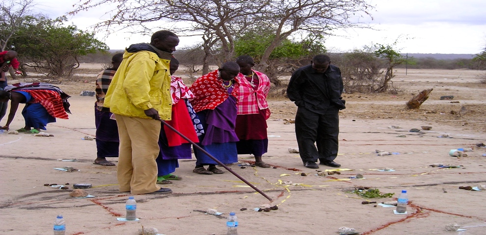
In order to understand the different resources in the villages and their spatial distributions, the SRMP supported the villagers in carrying out participatory mapping. They developed a base map showing all the resources shared by the villages. The villagers then produced individual and joint village land-use maps and plans. A joint village land-use agreement that detailed and ultimately protected the shared grazing area, water points, livestock routes and other shared resources was drafted, signed and approved by the Joint Village Land-Use Association.
The three OLENGAPA village councils then established a Joint Grazing Land Committee made up of members from all three villages. The committee is responsible for planning, managing and enforcing by-laws applicable to the OLENGAPA as well as coordinating the implementation of the OLENGAPA land-use agreements and the joint land-use plan.
In the second phase, a fourth village joined OLENGAPA and doubled the shared grazing land available. In 2018, the Ministry of Lands approved and registered the village land boundary maps and deed plans for the four villages. In the end, each village assembly approved the joint village land-use agreement, which allocated 20,706.73 hectares of land (about 40 per cent of the total area of the villages) for shared grazing. The agreement is based on the rules and regulations related to current community use of the land and resources. By-laws for the management of the resources were developed and adopted.
Results
The project supported the development of a JVLUP for the OLENGAPA cluster, whose inclusion of an extra village resulted in an increase of the shared grazing area to 30,000 hectares. The project supported the first-ever registration of a grazing area, and in September 2018, a group certificate of right of occupancy (CCRO) was issued through JVLUP to the OLENGAPA livestock keepers association.
A recent survey revealed that there is now a higher degree of land tenure security among community members in the project areas and consequently greater willingness to invest in rangeland management activities. It is believed that the JVLUP has indeed strengthened land governance and security. Community members are now taking steps themselves to enforce the JVLUPs, raising issues such as encroachment with the district government. According to farmers, the rangeland condition has improved and there have been improvements in rangeland productivity.
Lessons Learned/Potential for replication
Lessons learned from this innovation indicate that:
- As long as the benefits are visible from the start, communities are willing to participate and support the process.
- Production of plans is not enough – investment is required to assist communities and other stakeholders in implementing the plan.
- There is a need for intensive preparation before the planning process, including ensuring that all stakeholders understand the JVLUP process and implications.
- Preferably, no village in the cluster should have an existing village land-use plan, allowing all villages to start the planning process in parallel before coming together.
- The process of village land-use planning is complex, resource-intensive and time-consuming. It is important to have adequate funds and skilled personnel in place.
- Important factors for replicating the approach are a focus on current land uses, awareness of conflicts and willingness of various stakeholders to participate in and support the process.
Next Steps
To scale up this innovation, long-term commitment is needed, from the village communities to national government. Land-use plans for neighbouring communities are also needed. To sustain the process, in addition to the community making their own contributions (in-kind and/or financial) to the process, funding can be sourced from elsewhere (e.g. the Ministry of Livestock).
The project has helped mainstream the process in government documents and has provided inputs to the development of government manuals, strategies and policies. It is anticipated that the Ministry of Livestock and Fisheries will be scaling up the approach in the coming years.
Solution Document Downloads
Last update: 09/08/2021


